The Middle Ages (476-1492)
Articles
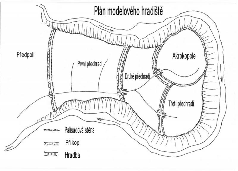
In this next part we must deviate from purely prehistoric fortifications. This is due to the fact that localities that have so far been identified in our territory as the seat of prehistoric cultures were extensively used at the time of the arrival of Slavs to our territory and new fortifications were again erected on the remains of prehistoric cultures. the first princely and royal castles stood on them in the form of strongholds, and on many of them there are castles or their abandoned ruins to this day. So we will try to transfer to the deep past and, if possible, connect it to the present.
The emergence and rocket spread of Islam is one of the most interesting phenomena in world history, the causes of which are still not sufficiently clarified. The area of ancient pre-Islamic Arabia was highly fragmented, both culturally and religiously. There were both astral cults and religious pantheons from neighboring areas - Baal from Syria, Coptic Christianity from Ethiopia and the Nabataean Christianism. The priesthood did not exist as a state, certain families only treated traditional shrines, such as the Kaaba in Mecca. Due to its location between the Persian Gulf and the Red Sea, the germinal urban population could feed on trade. The second, main component of the population was the opposite of civilization - wild nomadic tribes, which saw the robbery as a legal way to earn extra money.
1. Introduction In this work I deal with the reconstruction of the course of the Regensburg Trail, which, as is well known, led from Prague to Regensburg. It is assumed that the course of the journey in the early Middle Ages led from Prague via Beroun, Rokycany to the important early medieval center of Starý Plzenec, from where the road continued to Dobřany, Hradec u Stoda via Domažlice to Regensburg, Germany.
2. The development of trails If we realize what the term "long-distance trail" means at all, we will find that it is a route that served for regular human communication at a greater distance, from the very beginning of human existence.)
3. Status of previous research The interest in the Regensburg Trail began in the 19th century. Initially, the subject was not the road itself, but the border area, specifically the Czech-Bavarian border through which it passes. František Palacký expressed his first interest in leading the way, trying to pinpoint the location of the battlefield where the battle between Břetislav I and Henry III took place. in 1040. According to a study of the sources at the time, he was convinced that the road from Bavaria led through the Všerubský Pass. The same opinion was shared by Hermenegild Jireček, who spoke about the direction from the castle Chauby (Kouby) to Furth via Eschelkam to Neumarkt.
4. Method of work - model line of the Regensburg trail As already mentioned in the introduction, in this work I focused on the section starting in Starý Plzenec, which continued to the border with Germany. Based on the literature presented in the chapter Status of previous research, I plotted the map in the GIS program, which focused on the territory of four former districts - Pilsen - City, Pilsen - North, Pilsen - South and Domazlice. In order to create a preliminary model of individual sections from this area, which were subsequently examined in the field, it was still necessary to work with several types of maps.
5. The course of the Regensburg road If we want to consider determining the place where our border could be crossed in the simplest way possible, we must be aware of the landscape in which it is located. The border area with the Bavarian side of Germany is located in the places of the Bohemian Forest. Specifically, in this case, it is the Bohemian-Cubic Highlands, which freely passes into the Jezvinecká Highlands (Vejnar et al. 1984, 10). It reaches very high altitudes. The maximum values can be up to about 730 m above sea level. Therefore, it was very important at that time to choose a crossing point where it would not be necessary to overcome too many natural obstacles. Based on the studied literature and maps, I fully identify with the course of the trail, starting on the German side, which was designed by historian Eduard Maur (based on the studied work Rezenská cesta and the country trail in Domažlice).
6. Classification and creation of the database After the end of the field prospecting, all digital coordinates measured by the GPS Trimble device were imported into the Arcmap program, via ArcGIS 9.3. Now all points have gone through the same process as before the model was created. Orthophotomaps, maps of II. military mapping and the RETM raster map provided by the new version of the ESRI map server were used as background maps. Based on this, some imports had to be discarded. This happened when the markings on the map were not accurate enough.
7. Interpretation As I mentioned above, after the overall evaluation, a total of 55 imports (objects) were analyzed. However, this result represents a small sample that could be used to answer certain questions using formalized methods (Neustupný 2007, 134). Therefore, only non-formalized methods were used.
8. Dating Currently, several options are used to date the found relics of communication through direct or indirect dating. In case we need to find out the absolute data of individual imports, we can achieve this on the basis of historical reports, which inform about the given sections of a certain road. Another very important source is archaeological artifacts found directly on the site or in its vicinity, which were obtained by accidental finding, archaeological research or using a metal detector (Nový 2008, 12). This last mentioned method was successfully used, for example, in the research of the Golden Trail (Kubů - Zavřel 2009, 61).
Summary
The main objective of this study was to reconstruct the paths Regensburg particular period, which begins in Starý Plzenec and ends at the border of the Czech Republic in the early Middle Ages. After studying written or cartographic documents, the obtained results were subsequently verified using non-destructive research.
10. References
11. Summary
The main objective of this study was to reconstruct the paths Regensburg particular period, which begins in Starý Plzenec and ends at the border of the Czech Republic in the early Middle Ages. After studying written or cartographic documents, the obtained results were subsequently verified using non-destructive research.
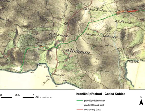
12. Attachments
In this work I focus on the reconstruction of the Regensburg Trail, which, as is well known, led from Prague to Regensburg. It is assumed that the course of the journey in the early Middle Ages led from Prague via Beroun, Rokycany to the important early medieval center of Starý Plzenec, from where the road continued to Dobřany, Hradec u Stoda via Domažlice to Regensburg, Germany.
A little English poetry for good night
Translation of a poem from the Anglo-Saxon Chronicle The Battle of Brunanburh
Governing the medieval monarchy was certainly not an easy task. Many medieval monarchs were convinced of this. The power of the king was constantly trying to limit some strata in society, especially the high nobility. Rich oligarchic families did not respect royal power in the state. It was this problem that led the Hungarian king Karol Róbert of Anjou to the battlefield near the village of Rozhanovce in 1312.
On July 15, 2002, it was 1030 years since the death of the Czech prince Boleslav I.
Boleslav I. is for me the most important politician of the Czech state, due to the fact that thanks to his political work we were not met by the fate of the Elbe Slavs (exterminated by the Germans) or the fate of the Danube Slavs (exterminated by the Hungarians). Boleslav I. is therefore actually the father of the Czech state and nation.
Topics
Subcategories